New update on flooding from the North as it continues its inevitable move South, confirmed by NASA satellite imagery.
Tropical Cyclone Kirrily hit the Central and North Queensland coast in late January 2024. The heavy rainfall caused much havoc in coastal areas, however, in the often-dry centre of the continent, locals welcomed a deluge such as this which is seldom seen. What could be described as a slow-moving inland sea in southwest Queensland shows the waters cutting along through the aptly named Channel Country. This is the parched landscape that scrapes across the Simpson Desert, flowing south through south-western Queensland to South Australia and down to Kati Thanda-Lake Eyre.
As of Mid-March 2024, water started flowing into Lake Eyre North and began to flow into the Warburton Groove, a channel that runs from north to south down the lake towards the low point at Belt Bay. The size of these floods is something that has to be seen to be believed, and one of the best places to view them, of course, is from above. The remarkable regeneration of vast Outback desert plains flooded by soaking waters brings with it flora and fauna, a miracle of Mother Nature.
The recent reports from ABC News below describes this slow moving flood. The satellite image below was taken on 13 April, 2024 by NASA and shows that we now have the ideal conditions to see the groove salt; that is, guests will not simply view a body of water; what makes this miracle of nature so special is all the contrast that can be seen – the dried salt lake areas, the wet salt lake areas and the water itself. Water flows down the Warburton Groove to continue filling Belt Bay which lies in the south western region of Lake Eyre. As at mid-April, the water level at Belt Bay was at 1.2m and rising. Madigan’s Gulf while not filled to the extent that Belt Bay is, still exhibits incredible panoramas of the dry becoming wet! The Coopers Creek system is flooding and this in turn flows south to Lake Eyre.
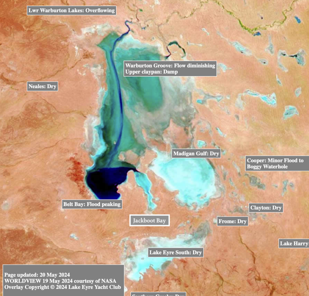
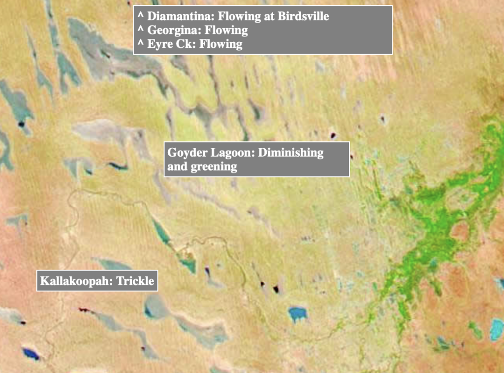
As of 19 May 2024, the new NASA satellite image below shows that Lake Eyre has continued to fill as the flood waters from the north have flowed further south. This is indicated by the dark navy colour in the map showing that the flood waters in Lake Eyre north have peaked this month at 1.4m. Lower Warburton Lakes are overflowing, the water that has inundated Belt Bay has now spilled over and is flowing into Jackboot Bay. The other NASA satellite image below shows the greening of the Diamantina as a result of the flooding that moved through the area earlier. Mother Nature’s regeneration is a sight to behold!
Travellers on the Lake Eyre & Flinders Ranges Airtour will be some of the lucky few to witness this incredible event of nature as floodwaters continue to pour into these regions. Marvel as our ‘flightseeing’ takes in:
The Flinders Ranges, Wilpena Pound, Birdsville, Marree Man^, Lake Eyre South, the Goyder Channel, the Southern end of Lake Eyre North, North east towards the Warburton River and North towards Birdsville as we follow the Diamantina River towards the iconic Outback town of Birdsville.
As at 13 April:

As at 19 May, 2024:
Our performers write excellent compositions to order, for which students receive only positive marks. Any subject, any topic – all this is within the power of the authors of our site. You can buy an essay online – you do not even have to leave the house, call up with the author. Placing an order is very simple.